Klamath River Recreation
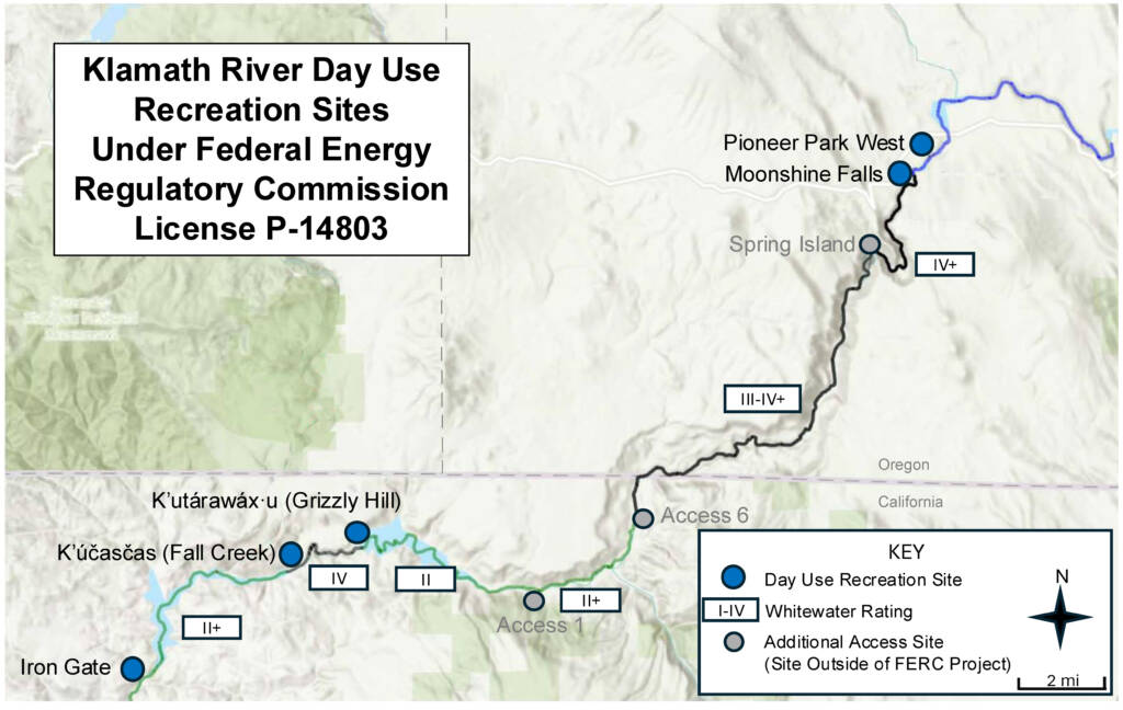
Five day-use recreation river access sites along the restored reach of the Klamath River at the previous J.C. Boyle, Copco, and Iron Gate reservoir areas are open for public use beginning August 1, 2025. Each site has a river access point, vault toilet, picnic table(s), limited parking, and bike racks.
All lands surrounding the recreation sites remain closed. No trespassing outside of the designated recreation site is allowed.
Please note, the river is undergoing natural changes as it reclaims the river channel. There may be hazards in the channel including but not limited to rapids, rocks, and downed trees. Users should always wear a life jacket when on the river and plan trips based on experience levels. Specifically, users should be aware of Class IV+ rapids, which are characterized by intense, powerful, and turbulent waters, downriver of the Pioneer Park West and Moonshine Falls recreation access sites in Oregon and downriver of the K’utárawáx·u (Grizzly Hill) access site in California.
The Oregon Department of Fish and Wildlife manages the recreation access sites in Oregon (Pioneer Park West and Moonshine Falls) and the California Department of Fish and Wildlife manages the recreation access sites in California (K’utárawáx·u or Grizzly Hill, K’účasčas or Fall Creek, and Iron Gate). Please direct any questions to the following and continue to check this website for information:
- Oregon Department of Fish and Wildlife, Klamath Watershed District Office: 541-883-5732
- California Department of Fish and Wildlife: 530-225-2300
- Klamath River Renewal Corporation (KRRC): info@klamathrenewal.org; and/or: 510-560-5079
The Oregon sites are supported by partial funding from the Oregon State Marine Board Boating Facility Grant Program, investing fees and taxes paid by motorized boaters for boating facility improvements and Waterway Access Grant Program, investing waterway access permit fees paid by nonmotorized boaters for boating facility improvements. The California sites are supported by funding from the Wildlife Conservation Board and Proposition 68 State of California Parks & Water Bond 2018.
In addition, work is beginning on an interpretive Heritage Trail connected to the K’účasčas (Fall Creek) and K’utárawáx·u (Grizzly Hill) recreation access sites. Located along the ancestral lands of the Shasta Indian Nation, this trail will offer opportunities for visitors to engage deeply with cultural traditions and transform outdoor recreation into meaningful cultural connection. The trail is expected to open in summer 2026. Please continue to check here for updates on the status of the trail.
Recreation Site Access Information
Oregon
Pioneer Park West
- Open daily from 7:00am – 7:00pm unless otherwise posted
- Users should be aware of Class IV+ rapids downriver of the access site. Nonadvanced boaters should exit at this site.
Moonshine Falls
- Open daily from 7:00am – 7:00pm unless otherwise posted
- Users should be aware of Class IV+ rapids downriver of the access site. Nonadvanced boaters should exit at this site.
California
K’utárawáx·u (prounounced ku-ta-ra-wa-hhu) (also known as Grizzly Hill)
- Open daily from sunrise to sunset unless otherwise posted
- Users should be aware of Class IV+ rapids downriver of the access site. Nonadvanced boaters should exit at this site.
K’účasčas (pronounced ku-chas-chas) (also known as Fall Creek)
- Open daily from sunrise to sunset unless otherwise posted
Iron Gate
- Open daily from sunrise to sunset unless otherwise posted
Interpretive Heritage Trail
- Expected to open in summer 2026
- One trail section will connect to the K’účasčas (Fall Creek) recreation access site and one will connect from the K’utárawáx·u (Grizzly Hill) recreation access site
- The trail will feature interpretive signage, linguistic markers, and designated sacred viewpoints
Recreation Site Locations

Recreation Plan Materials
Final Recreation Plan (December 2022)
- Draft Recreation Plan – December 2021
- Draft Recreation Plan – February 2021
- Recreation Plan Update Webinar Presentation – December 5, 2019
- Recreation Plan Update Webinar Presentation – August 21, 2019
- Recreation Plan Update Webinar Presentation – May 29, 2019
- Recreation Plan Update Webinar Presentation – January 30, 2019
- Draft Recreation Plan: Definite Plan Appendix Q – June 28, 2018
